A Saturday afternoon stroll, out to the end of Red Lane and back.


A Saturday afternoon stroll, out to the end of Red Lane and back.
It could rain – we might need an umbellifer… No shortage of them, of several varieties, in the lanes today. Lots of fried eggs in the hedgerow too (I think perhaps they may be wild roses…). A walk around the lanes from Willey, including Round Hill and Ned’s Lane – a most enjoyable outing for another grey afternoon.


View OS Map on Streetmap http://www.streetmap.co.uk/map.srf?X=367580&Y=297955&A=Y&Z=120
A warm but overcast afternoon, in and around Ironbridge


It’ll soon be midsummer’s day – it should be warmer! Later, the sun breaks through the clouds and the temperature rises a little. It’s comfortable walking weather anyway. The hedgerows around Kenley Ridge know it’s summer – there’s plenty of colour!


View OS map on Streetmap http://www.streetmap.co.uk/map.srf?X=356695&Y=301410&A=Y&Z=120
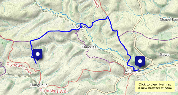
Friday 11 June: a walk from Llangunllo to Knighton, in weather that makes the landscape feel very soft and green. There’s dampness in the air, and for a time we have our waterproof tops on, but they’re hardly necessary. “We ought to see a red kite or two” – yes, we did! One landed on the fence, just about within camera range, and perched for a while (looking soggy and grumpy) before, with little more than a flap, gliding away, making the most of the lightest of breezes.
This is a walk of two halves – Wales and England (Shropshire). Knighton is a Welsh town, but its railway station is in England (just, a matter of yards). We leave the train at Llangunllo (Wales), and walk to the crest of the ridge of Wernygeufron, which descends very gently to the hamlet of Lloyney. There, we cross the river Teme to find ourselves in England again (at Llanfair Waterdine). A steady pull, steep in places, takes us up to Offa’s Dyke and another enjoyable ridge. Finally, a steep descent leads us down to the river once more. Walking downstream and eastwards, we find a sign: Croeso i Gymru – Welcome to Wales. Fifteen minutes later, a pint (of Shropshire beer, from Bishops Castle) is well-earned refreshment – croeso i gwrw! – welcome to ales…


")


")


View OS map on Streetmap http://www.streetmap.co.uk/map?X=325225&Y=273636&A=Y&Z=126
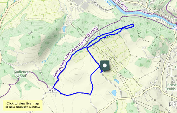
Walking with the camera on a grey day, across the fields and along the lane to Wyke, then on to Benthall Edge. We’ll turn back at the chocolate seat and return through the woods to Benthall Lane and back to the start.


View OS map on Streetmap http://www.streetmap.co.uk/map?X=365515&Y=302540&A=Y&Z=120
An hour with the camera, following quiet roads, lanes and paths through the fields, enjoying the summer sunshine.


Saturday 5 June: a trip to the beach, this time near Yellow Craig, just to the west of North Berwick. There are several islands in this part of the Firth of Forth – the Bass Rock is probably best known; Craigleith lies closer to North Berwick and just offshore is Fidra.


View OS map on Streetmap http://www.streetmap.co.uk/map?X=351725&Y=686253&A=Y&Z=120
Friday 4 June: A coastal walk from Dunbar to Hedderwick Sands, at the mouth of Scotland’s river Tyne – and back along the beach of Belhaven Bay, with views to Dunbar ahead, and the Bass Rock behind.


View OS map on Streetmap http://www.streetmap.co.uk/map?X=365395&Y=678695&A=Y&Z=120
… Behind the isles – at this time of year, South Harris. There have been times when, during our stays on Skye, we haven’t seen what we would call a sunset (there have been times when we haven’t even seen the Western Isles), but this time we’ve had some clear skies and a nightly spectacle in the west. The sun sets around 10pm in these parts in late May…


