Rails and pools

Wednesday 27 Feb: We’re enjoying the last day of the warm sunny spell, walking from the top of Coalbrookdale to the pools at Dawley, in part following the route of old pre-railway age wagonways. We’ll cross (on public footpaths) some real railways too – the disused line to the power station and the soon-to-be-reconstructed line from Horsehay. The various pools, dating from the same era as the wagonways, are likewise associated with the early iron-making industry in these parts. They look pleasantly rural in the bright sunshine.

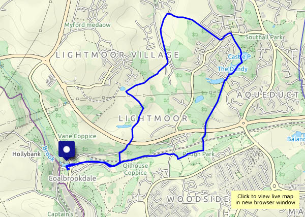
View OS map on Streetmap http://www.streetmap.co.uk/map.srf?X=367790&Y=305706&A=Y&Z=120

Wood and stone: Clive and Grinshill

The morning’s fog has cleared, though it’s still quite hazy north of Shrewsbury. We’re following our usual route, with variations – out by the path around the south side of the hill, turning back at Clive and heading for the “summit” (just 630 feet, or 192m), then back through the old quarries. It’s a popular spot, especially on a fine sunny day.

View OS map on Streetmap http://www.streetmap.co.uk/map.srf?X=352205&Y=323656&A=Y&Z=120

Bannister’s and Traps

Saturday 23 February: A walk from Wenlock, on a fine dry afternoon. It’s almost “fine sunny afternoon”, but an approaching weak weather front takes the sunshine away (it didn’t get far – there was clear blue sky not too many miles to the east). The woods are quiet – there’s no wind. In Bannister’s Coppice, a rustling to our left reveals a herd of deer, perhaps 20 or more, well-hidden and impossible to photograph. There aren’t any deer in Traps Coppice today – just hundreds of pheasants, whose likely life expectancy is probably very short…

View OS map on Streetmap http://www.streetmap.co.uk/map.srf?X=362175&Y=301916&A=Y&Z=120

Highest in the county

We stood  above everyone else in the county at about 2.45 this afternoon, when we gazed out from Abdon Burf on Brown Clee, Shropshire’s highest point (1772 feet, or 540m). It’s a good place to be on an afternoon like this – positively springlike, it would be a crime to stay indoors. It’s quiet too – despite being school half-term week, we saw just four other people while we walked. Wonderful!

View OS map on Streetmap http://www.streetmap.co.uk/map.srf?X=360130&Y=285861&A=Y&Z=120

In Mortimer Forest

We’re walking from Ludlow into the hilly forest to the south-west, a route which takes us into Herefordshire, via the delightfully-named Sunnydingle Cottage to a summit at High Vinnals. 375m (1230 feet) is no great height, but the view is tremendous. That is, it would be, if it wasn’t for the showers of light rain here and there (no, the weather isn’t being as friendly as we’d expected). We return past Mary Knoll House, slithering downwards on the slippery clay, back to very welcome tea and cake, just right for the journey home.

View OS map on Streetmap http://www.streetmap.co.uk/map.srf?X=349560&Y=273526&A=Y&Z=120

Bridgnorth

A short wander on a pleasant afternoon. The day had been dull and gloomy around lunchtime, but things improved. A southbound train was leaving as we crossed the bypass – none other than 75069. in action again after a lengthy and expensive overhaul. There are other “locomotives” dotted around Bridgnorth, colourful but of unusual design…

A walk to Wenlock

A couple of weeks ago, we caught the bus to Much Wenlock and walked back (see A walk from Wenlock). Today, one of us will be spending some time in Wenlock – if I time it right, I can get a lift back. It’s more-or-less the same route, but in reverse the views are different – mostly. It’s a fine sunny day – not a cloud in the sky – too good to waste!

View OS map on Streetmap http://www.streetmap.co.uk/map.srf?X=364795&Y=301296&A=Y&Z=120