Stiperstones strolling

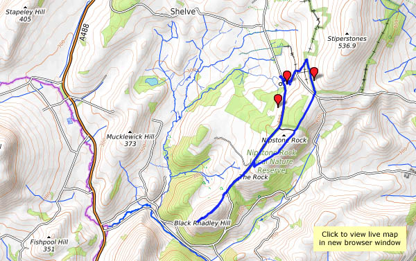
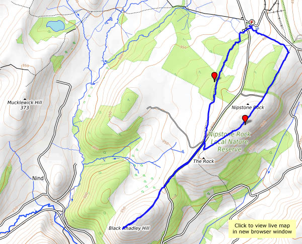
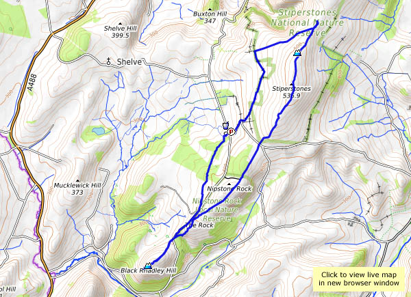
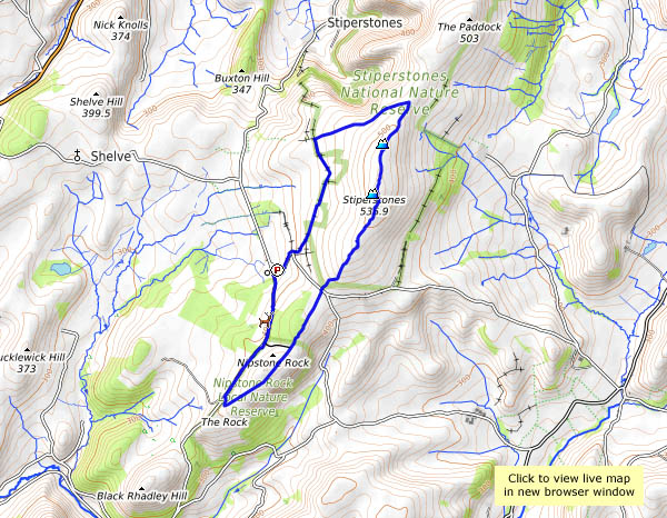
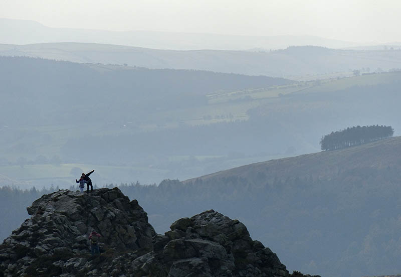
It has to be a stroll – the path along the ridge is far too rough for any speed. Slow progress is essential if the view is to be appreciated without broken bones… The distant views are wonderful, in all directions; closer, there are other items of interest – a red kite, toadstools (just a few), a fine hairy coo – and the alpacas… It’s a great day to be up here – fine and clear, bright and cool (and breezy).  Nevertheless, it’s good to get back to the Bog too – the cakes are splendid. What an enjoyable day!

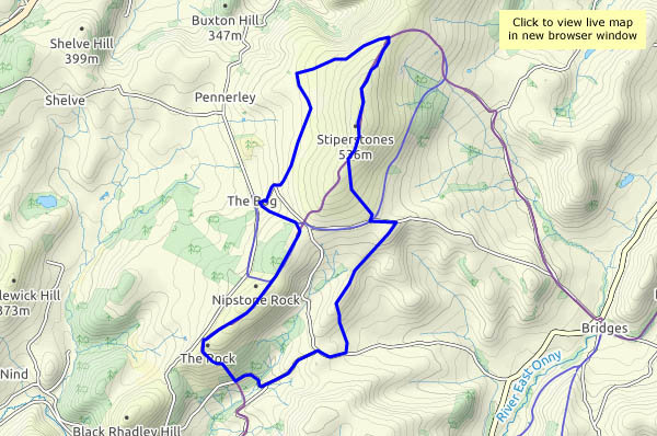
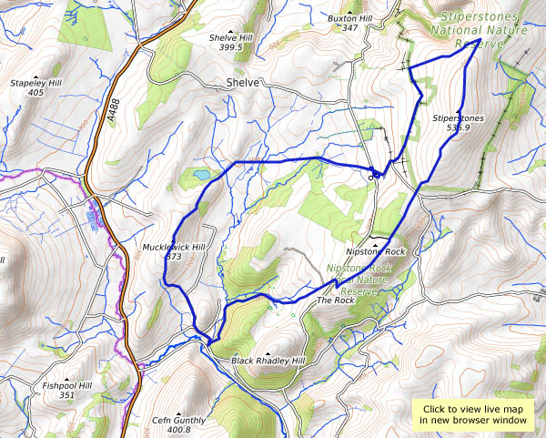
View OS map on Streetmap http://www.streetmap.co.uk/map.srf?X=336175&Y=298046&A=Y&Z=120

Mucklewick and Stiperstones

Thursday 13 September: a cool fresh day on Shropshire’s wild western fringe – this weather is great for a walk in these quiet (apart from the gunfire) hills. From The Bog, we’ll head for Mucklewick Hill (whose summit may be lower than our starting point), then down to Nind and up past the shooting range, where it sounds like they’re playing with their rocket-propelled grenades today. After a late lunch below The Rock (imaginative names in these parts), we’ll follow the ridge northwards, past the Devil’s Chair (he’s not sitting today, fortunately), before dropping back to the start, for tea and cakes at the Bog Centre (was the walking just an excuse?).

View OS map on Streetmap http://www.streetmap.co.uk/map.srf?X=335650&Y=297831&A=Y&Z=120

Bog, Black Ditch and Black Rhadley

There’s barely a cloud in the blue sky – it’s a day that’s too good to waste. We’re off to The Bog, for a walk along the southern ridge of the Stiperstones to Black Rhadley, and when we get back, the Bog Centre is open for tea and cakes. What more could one ask? That was intended to be a rhetorical question, but I’ll answer it anyway: “peace and quiet” – and yes, we had that too. Despite the weather being unusually good, we saw hardly anyone else on our walk, the shooters at the range were quieter than normal and even the dogs in the kennels failed to disturb the calm (there must have been others about – the cakes had nearly all gone!).

Bog Visitor Centre

View OS map on Streetmap http://www.streetmap.co.uk/map.srf?X=335045&Y=296846&A=Y&Z=120

Kites and alpacas…

It’s busy on the Stiperstones this afternoon – lots of black sheep, at least two red kites, a grouse, a good number of alpacas and several llamas. There were quite a few people too, in the more popular parts – something to do with it being half-term, and the weather fine, clear and sunny? Young parents and children, a largish party armed with pointy sticks and a large group of – were they schoolteachers? Our greatest fear was that they might arrive at the Bog before we did, and that it might be packed anyway. Our fears were unfounded – just a medium-sized group around one of the tables, and it seems one of us knew them all anyway, so that was OK. The tea and cakes were, as ever, excellent (and well-earned, of course).

The Bog visitor centre

View OS map on Streetmap http://www.streetmap.co.uk/map.srf?X=336375&Y=297956&A=Y&Z=120&ax=335475&ay=299701

A short walk on a long day

It’s the longest day of the year today – it has been one of the hottest too, though we managed to keep comfortable on a very pleasant short walk at the south end of the Stiperstones ridge, with a visit to the top of Black Rhadley. It was (relatively) cool in the woods, and on top there was a good breeze blowing. We celebrated with half a punnet of English strawberries (we’d eaten the other half at lunchtime!) – best strawberries I’ve had for many years too. There are other berries up here. The birds have obviously been eating something bilberry-coloured – but it will be a good few weeks before they’re ripe. In between the baby bilberries, we spotted interlopers, which I reckon were crowberries. Didn’t try them… We certainly wouldn’t have tried the fine fungus we’d found in the woods earlier. A common earthball with a stalk? Is there such a thing?

The tea / cold drink and cake at the Bog Centre were good, as ever.

View OS map on Streetmap http://www.streetmap.co.uk/map.srf?X=334995&Y=296626&A=Y&Z=120

Black Rhadley

The beginning of April marks an eagerly-awaited turning point in the South Shropshire calendar – the Bog Centre opens up for the season. That fact (with its implied prospect of excellent cakes, scones etc.) was the clincher when I asked my friend where he thought we might go for today’s walk.

Before we can enjoy those refreshments, of course, we have to earn them, and we haven’t even had lunch yet. Black Rhadley, overlooking the river West Onny as it winds through the Linley Hall estates, should be a suitable spot. It was, too – extensive views in all directions, and wonderfully quiet – just the birds, and there’s that curlew again. Lunch over, we head northwards along the Stiperstones ridge, as far as the head of Perkins Beach, where we turn back toward The Bog for tea and Stiperscones.

View OS map in Streetmap http://www.streetmap.co.uk/map.srf?X=335620&Y=297406&A=Y&Z=120

Kites above the Devil’s Chair

They must have thought as we did – that it was a perfect day for the hills, almost too good for mid-March. A cloudless sky, warm sunshine, cool air and the lightest of breezes – much better than mid-summer. Fewer people about, but at least four red kites. First there was one on his (or her) own, then another, then a pair, hurrying away to the north – and moments later, another pair circling to our south. The alpacas and llamas were enjoying the sun too. This is south Shropshire, isn’t it? It’s hard to be sure sometimes.

View OS map on Streetmap http://www.streetmap.co.uk/map.srf?X=336680&Y=299146&A=Y&Z=120

Stiperstones in October

We’re walking the length of the ridge, from Snailbeach to the Rock, on a fine autumn day with the promise of some sunshine. The starting point is significant – one of our objectives is the Bog Centre for tea and cake – if we’d started there, it might have been closed by the time we returned (and that would never do!). So we’re heading out past Lordshill chapel and the Hollies, and two-thirds of the way around this very enjoyable route we come to the Bog, feeling suitably peckish. We return by the paths skirting Perkins Beach and Crowsnest Dingle, back to Snailbeach past that very fine octagonal chimney high up in the woods. And yes, after a dull start, the sun did shine, though it looked like we’d seen the last of it when we arrived back in Snailbeach. We hadn’t, of course – inevitably, it shone brightly while we drove home, floodlighting the autumn trees against a dark sky. Wonderful – but no photos.

View OS map on Streetmap http://www.streetmap.co.uk/idld.srf?X=336585&Y=299306&A=Y&Z=120&lm=1