Rubha na h-Aiseig

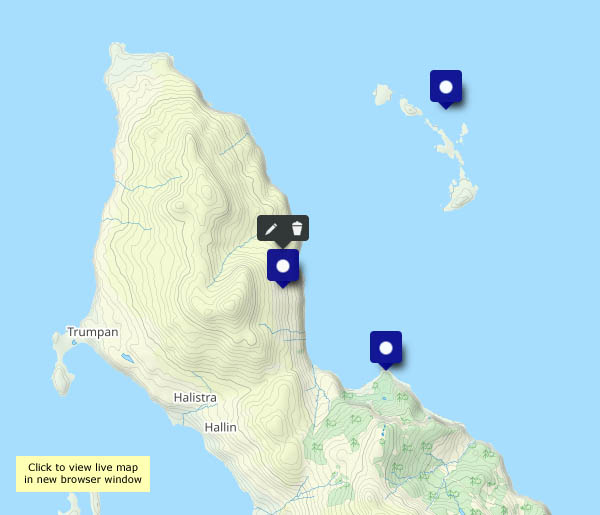
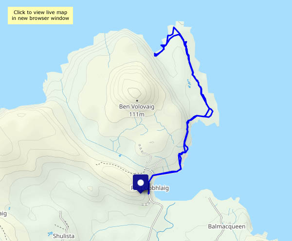
24 May continued: Starting from the same place as yesterday’s walk, I’m heading in the opposite direction. At first I skirt the clifftops, with one or two rather exposed spots between the fence and a near-vertical drop to the sea. The views to the south and east are extensive – Sròn Vourlinn’s startling peak dominates the near distance; the north-western highlands form an intriguing horizon. Descending to the grassy foreshore, a very faint path leads to the ‘Ferry Point’, where once perhaps there was a connection to the island of Trodday, a mile or so to the north. Remains of a couple of black houses, and a curious gap in the stony shore where a boat might possibly have been dragged to and from the sea, are the only clues remaining.
As I wander back, in no hurry, a seal pops up just yards from the rocks to see what I’m doing. Oystercatchers flit noisily along the shore.  Butterwort catches the eye in the grassland – and someone has buried a couple of camels…

View OS map on Streetmap http://www.streetmap.co.uk/map?X=143829&Y=875753&A=Y&Z=120

Before the rain…

It’s going to rain tomorrow – all day, with the possibility of thunderstorms. It’s trying to be dry this afternoon – we’d better get out there, for a quick walk around Willey and the Smithies – up Round Hill, down Ned’s Lane and back via Bould Lane and Britons Lane. Despite the wind, the interest is in the detail today – when it stays still…

View OS map on Streetmap http://www.streetmap.co.uk/map?X=367290&Y=298005&A=Y&Z=120

Later that day…

23 May (continued): We’re not going to enjoy any sunshine, but will probably enjoy an hour or so on the rocks at Camas Mor – especially if the rain holds off. The air is clear; low cloud hangs over the Harris hills, brightly lit where higher cloud thins. A bulk carriers steams south through the Minch, briefly catching the sun. On the rocks, there’s lichen galore, and clumps of sea pink add a splash of colour.

View OS map on Streetmap http://www.streetmap.co.uk/map?X=137039&Y=870788&A=Y&Z=120

Balmacqueen and Connista

23 May (Skye continued): There are still plenty of showers around, but the afternoon looks like staying dry. We’ll take the waterproofs, just in case. We’ve walked from the small parking space at Port Gobhlaig many times, but we’ve never explored the lane from Kilmaluag to Connista – let’s try it! We’ll head along the path by the shore to Balmacqueen, then up to the main road and down to the bridge over the Kilmaluag River, whose clear peaty water looks like diluted Guinness… It’s a there-and-back-again walk to Connista – a very quiet one, with wonderful views. And no, we didn’t need the waterproofs.

View OS map on Streetmap http://www.streetmap.co.uk/map?X=143339&Y=874333&A=Y&Z=120

Rainy day

22 May: A wet day. Will there be any let-up? The window below sums it up nicely – apart from a few minutes around 6pm, when the rain stops. Light streams through the clouds to illuminate the settlement of Geary, beyond the Ascrib islands, around eight miles away across (sea) Loch Snizort. The little promontory at Oans is visible most days, but it doesn’t stand out – you wouldn’t know it was there. For a few minutes, the light falling through the rain brings Oans into sharp relief. Then the rain returns. Tomorrow will be better, won’t it?

View OS map on Streetmap http://www.streetmap.co.uk/map?X=127519&Y=860678&A=Y&Z=120

Borgh na Sgiotaig

20 May: That’s its Gaelic name. In English, it’s Bornaskitaig. Yes, we’re at our northern office, for just over a week on Skye. We haven’t chosen a very good week – a rainy spell seems to have arrived with us. The evening looks like staying dry, though there are showers around. We’ll park at the village hall, and wander around the quiet lanes through to the cliff top above Lùb an Sgòir (Score Bay…). The shadows are lengthening, and the clouds looking ominous as we head back towards the car.

View OS map on Streetmap http://www.streetmap.co.uk/map?X=138160&Y=870845&A=Y&Z=120