By Loch Langaig and Loch Hasco

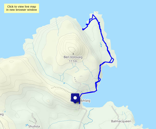
… to Sròn Vourlinn I will go (to the tune of “Tangle o’ the Isles” perhaps?)

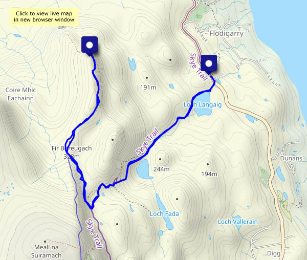
Wednesday 19 October: It’s a fine, bright afternoon, perfect for the hills. Sròn Vourlinn is not a particularly high hill, but its shape is impressive, the view from the top is extensive, it’s in an astonishing area of impossible pinnacles and ridges – and being about a third of a mile beyond the range of most visitors, it’s quiet. Really quiet!
The path up past the two lochs meets the popular tourist path from the Uig-Staffin road in a rocky hollow, and suddenly there are numerous other people. Some of them are noisy – don’t they understand? Why are they here? Ah – I see. It’s so they can take selfies. From the convergence of the paths, the way climbs to Fir Breugach, where there’s a slightly awkward rocky step onto the main ridge. Here, most of the others seem to turn back along, and up, the ridge. Some will continue the way I’m going, but they only seem to go as far as the first (and possibly slightly higher) summit of the Sròn Vourlinn ridge. Then they take a selfie, turn around and head back again. Beyond this point, I’ve got that final third of a mile to myself, and at its northern tip, I’ll stop, sit down and take it all in (along with a square of chocolate…). This place is far too good to hurry!

View OS map on Streetmap http://www.streetmap.co.uk/map?X=145464&Y=870575&A=Y&Z=120

Bornesketaig cliffs

Tuesday 18 October: Duties done, I’m allowed out. Taking the car as far as the village hall, I’m walking along quiet roads to the grassy clifftop, where there are no paths, but the way is obvious… In the clear air, the hills of Harris, around 25 miles distant, seem closer than usual. Like my Flodigarry walk, I’ve got this little part of Skye to myself (and the sheep)

View OS map on Streetmap http://www.streetmap.co.uk/map?X=137859&Y=870997&A=Y&Z=120

Portree: loch and harbour

Tuesday 18 October: A morning in Portree. As tends to happen, I’m on chauffeur duties, taking the household authorities in to the island capital so that they can visit shops, the bank etc. Fortunately, my presence is not required (quite the opposite!) so I’m free for an hour or so, to wander with the camera on this fine cold morning (what a difference after that dismal Monday).

View OS map on Streetmap http://www.streetmap.co.uk/map?X=148364&Y=843375&A=Y&Z=120

Flodigarry shore…

Sunday 16 October: Stones and seals! Silhouetted against the southern horizon, I thought they were rocks, until they began to wriggle…

We arrived at our ‘northern office’ yesterday, after driving more than 300 miles, from Dunbar to the northern end of Skye’s Trotternish peninsula. I need a leg stretch – I’ll aim for the shore near Flodigarry. The route down to the sea is clearly marked and easy; the shore itself is very stony – bouldery for long stretches. It would be easy to turn an ankle, and there’s no-one else around. So progress is very slow – just under a mile taking just under an hour! Admittedly, I stopped to watch the seals for a while. Ascent from the shore isn’t easy either – the ground is steep and uneven, to put it mildly. Possibly one of the longest short walks I’ve done for many years! Nevertheless, it’s been a most enjoyable outing, just what was needed after that long journey.

View OS map on Streetmap http://www.streetmap.co.uk/map?X=146710&Y=870855&A=Y&Z=120

Hinnisdal forest roads

27 May – last day on Skye. It rained all day yesterday – heavy blustery showers, of the kind which seem to ‘merge into longer periods of rain’, as the Met Office likes to put it. Today will be altogether quieter – the wind has dropped, and I’m heading for gentler scenery, as seen from the forest road in Glen Hinnisdal. That should be ‘roads’, plural – at the start there are paths leading off to left – ‘Rathad na t-aibhne’ (river road) – and right ‘Rathad an t-seann bhaile’ (old town road). We’ll head for the old town (a few stones in the forest!) before wandering up the glen for a mile and back again, this time taking the river road to visit the magnificent falls on the abhainn Hiniosdail. Very pleasant, and definitely quieter – but there’s still some rain about.

View OS map on Streetmap http://www.streetmap.co.uk/map?X=140850&Y=857595&A=Y&Z=115

Keep off the rocks!

25 May (we’re still on Skye): It’s been blowing hard all day, the showers coming thick and fast – and heavy. To get caught in one would be to get soaked. Then, late in the afternoon, there’s a bigger break in the cloud – might it stay dry for a while? Let’s chance it – a leg stretch from the village hall down to Camas Mor, where the waves on the rocks could be fun… After an enjoyable half-hour or so, clouds begin to obscure the sun – there’s another big shower coming. If we walk quickly, will we stay dry?

View OS map on Streetmap http://www.streetmap.co.uk/map?X=137039&Y=870788&A=Y&Z=120

Rubha na h-Aiseig

24 May continued: Starting from the same place as yesterday’s walk, I’m heading in the opposite direction. At first I skirt the clifftops, with one or two rather exposed spots between the fence and a near-vertical drop to the sea. The views to the south and east are extensive – Sròn Vourlinn’s startling peak dominates the near distance; the north-western highlands form an intriguing horizon. Descending to the grassy foreshore, a very faint path leads to the ‘Ferry Point’, where once perhaps there was a connection to the island of Trodday, a mile or so to the north. Remains of a couple of black houses, and a curious gap in the stony shore where a boat might possibly have been dragged to and from the sea, are the only clues remaining.
As I wander back, in no hurry, a seal pops up just yards from the rocks to see what I’m doing. Oystercatchers flit noisily along the shore.  Butterwort catches the eye in the grassland – and someone has buried a couple of camels…

View OS map on Streetmap http://www.streetmap.co.uk/map?X=143829&Y=875753&A=Y&Z=120

Later that day…

23 May (continued): We’re not going to enjoy any sunshine, but will probably enjoy an hour or so on the rocks at Camas Mor – especially if the rain holds off. The air is clear; low cloud hangs over the Harris hills, brightly lit where higher cloud thins. A bulk carriers steams south through the Minch, briefly catching the sun. On the rocks, there’s lichen galore, and clumps of sea pink add a splash of colour.

View OS map on Streetmap http://www.streetmap.co.uk/map?X=137039&Y=870788&A=Y&Z=120