The ferry

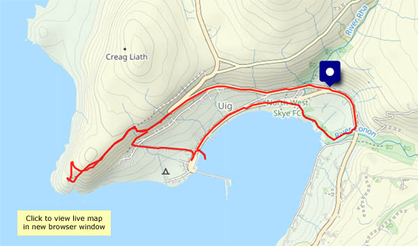
I have to be in Uig this afternoon (a shopping trip!): I’ll make the most of the short journey with a walk up to the headland above the bay, to see the ferry (the MV Hebrides, or Innse Gall) arrive and depart. It’s a fine bright afternoon; there’s a cool breeze but at the tip of the headland there’s a comfortable little rock seat, which provides shelter and a great view of the pier. There are corncrakes down below in the grasslands and there’s a cuckoo somewhere nearby – but there’s no-one else around (I don’t think the visitors in their cars, struggling to avoid each other and the truly appalling potholes, will have heard them. Their loss!). This is a perfect place to idle away an hour.

View OS map on Streetmap http://www.streetmap.co.uk/map?X=138250&Y=863793&A=Y&Z=115

Heribusta, Peingown and Hungladder

Friday 6 June: The morning should stay dry; we could have showers in the afternoon (we didn’t…). A morning walk should be pleasant, if rather cool. I’ll follow the very quiet road from the village hall, up through Heribusta, past the cemetery and museum (quite a few visitors here, on the short walk to Flora Macdonald’s grave) and back down the main road. The latter is surprisingly quiet too.  Not complaining…

View OS map on Streetmap http://www.streetmap.co.uk/map?X=139450&Y=871025&A=Y&Z=120

Cuckoo, curlew and corncrake

Thursday 5 June: an evening wander. The observant will already have noticed that the visible wildlife is none of the above… The hare was silent; posed for one quick photo then hurried away. But along the rough lane to Monkstadt, the silence of a still north Skye evening is profound. The cuckoo was over to my left, towards the hill; down towards the shore a curlew bubbled. Then the sound I’d hoped I might hear, a distinctive “creak creak, creak creak” that accompanied me back towards the start. “Come out and listen!” (No photos – audio only!)

View OS map on Streetmap http://www.streetmap.co.uk/map?X=138235&Y=867930&A=Y&Z=120

Balmacqueen: white waves, black rocks

There’s sufficient breeze to make white waves on the black rocks of Balmacqueen, and the sun’s doing much better today… I’ve walked this way several times, but it never fails to please, with a fine rocky foreground and extensive views. To the east are the mountains of mainland Scotland; to the north-west are the rugged hills of Lewis. Between them is open sea – next stop (well over the horizon!) the North Pole…

View OS map on Streetmap http://www.streetmap.co.uk/map?X=144323&Y=874438&A=Y&Z=120

Glenhinnisdal: the sunny side

It would have been, if the sun had shone… It tried, and eventually succeeded, but not until I was back from this walk up the glen of the Abhainn Hiniosdail. We’ve walked up the south side many times – a pleasant track through the community forest, with some interesting side-paths. Today I’m on the surfaced road – potentially brighter, and the views are different, but harder on the feet…

View OS map on Streetmap http://www.streetmap.co.uk/map?X=140929&Y=857850&A=Y&Z=120

The ferry and the fairies

Uig: after two days of rain and strong winds, there’s a dry afternoon in prospect. The southerly wind’s still quite strong – mid-40s mph – so some shelter would be good, as would a dry surface to walk on. The Fairy Glen! I was reluctant – last time I was here it was crawling with visitors, but it shouldn’t be too bad in early March. (It wasn’t – a few others, all heading for Castle Ewen, were easily avoided). Fairies notwithstanding, Glen Conon is an attractive and peaceful valley, with some magnificent waterfalls on its northern slopes.
As I set out, the ferry was docking at Uig pier. When I next overlooked the bay, on my way back, it was just rounding the headland on its way out. Nice timing for a most enjoyable outing!

View OS map on Streetmap http://www.streetmap.co.uk/map?X=140673&Y=863556&A=Y&Z=120

Above the Gold Cave

Those five fine days are gone, and it’s grey. It could rain, but I might be lucky. After a busy morning, a last leg stretch would be good – tomorrow we’re on the road again. The clifftops at Bornesketaig  would be good, and I can look down on the rocky shore around the Gold Cave (yes, I was lucky – the rain held off)

View OS map on Streetmap http://www.streetmap.co.uk/map?X=137805&Y=871090&A=Y&Z=120


Sròn Vourlinn and the Quiraing

Another favourite route in this part of Skye. It will be busier than the other walks I’ve enjoyed during this spell of wonderful weather, but the scenery is spectacular. It’s fairly quiet at first, up past Lochs Langaig and Hasco, but there are plenty of others on and around the pinnacles beside my route to Sròn Vourlinn. There’s no-one else at that splendid peak though. The silence is wonderful.
Retracing my steps, I decide to continue in the other direction to the Quiraing. I won’t scramble up into the rocky stronghold – the path there is a good vantage point for photos.
Finally, descending once more past the two lochs, what’s this? A highland wedding!

View OS map on Streetmap http://www.streetmap.co.uk/map?X=145598&Y=870111&A=Y&Z=120

Gull’s eye view

Up in the clouds above Uig! I very nearly abandoned this idea. I’d driven down for today’s paper, with the intention of walking up to the headland to see the ferry go out, but the fog was quite thick. Perhaps I should drive over to the other side – Staffin or Flodigarry perhaps? I drove up the hill towards the hairpin bend. Was the sun trying to break through? Back down to the triangle, boots on, camera over shoulder, fingers crossed.

As I walked up the road and along the first stretch of the path, I heard the ferry arriving (yes, pom pom pom pom – see yesterday’s post – and long blasts of the horn) but I couldn’t see it at all. Onwards up to the ridge – is there some blue up there? The view to the north opened out – a sunlit landscape of thinning, clearing mist. I’ll sit on the rocks overlooking the bay and hope! Another long toot of the horn, still can’t see the pier or the ferry – then there it was, emerging in most spectacular fashion and heading out towards Lochmaddy. Within perhaps 15 minutes, Uig bay was completely clear and plain as day – bright sunshine and brilliant white banks of mist in the distance. I made the right decision!

I retraced my steps on the headland, dropped down to the pier, along the road, through the woods and back to the start, but the best of the afternoon was behind me…

View OS map on Streetmap http://www.streetmap.co.uk/map?X=138825&Y=863887&A=Y&Z=120

Day’s end

Friday 20 September: The rest of the story of yesterday’s remarkable weather… The view from the top of the road, above Uig, was worth a couple of photos. Later in the evening, things became more interesting. I could hear the ferry on its way out to Lochmaddy – the usual distant “pom pom pom pom” of the engines, but also a periodic hoot of the (fog?) horn. As it headed west, it disappeared, but the reassuring “pom pom pom pom” continued long after. An hour or so later, the sun is setting behind Berneray (I think), and mist is gathering in the low-lying ground between my vantage point and the sea.
This morning (21 Sept) it’s foggy again. The forecast says it will clear: fingers crossed!