A grey day in Uig

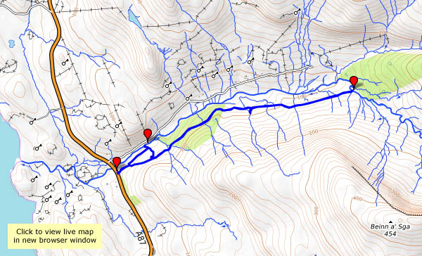
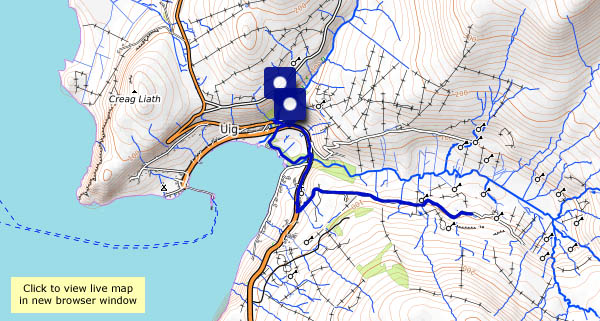
Saturday 18 August: we’ve been on gardening duties all morning. This afternoon, we need to go down to Uig to pick up supplies – we could have a leg stretch too. It’s a grey afternoon, but the rain seems less likely. The waterfall on the river Rha is a good start, then we’ll follow the shore path to the river Conon – and walk up the road as far as the Fairy Glen. The once-quiet side road is now busy with visitors, who struggle to park when they reach their destination. On foot, we can simply enjoy the scenery.

View OS map on Streetmap http://www.streetmap.co.uk/map.srf?X=140105&Y=863575&A=Y&Z=120

Waternish and Dunvegan…

Thursday 16 August: Sunshine and showers. We’re out in the car, exploring Skye’s north-western arms. At Trumpan, at the end of the road, there’s a ruined church overlooking Ardmore point, with views to Dunvegan Head. Later, we’ll drive past the throngs of tourists at Dunvegan Castle, and onto the low cliffs overlooking the loch, where we can watch the seals on the rocks below. Unlike the poor visitors in the open boats, we can scuttle back to the car when the showers blow across…

Soggy Skye

We were at our “northern office” last week. Throughout the summer, we’ve been wishing for rain. On the long drive up, it rained, inevitably. The forecast for Skye wasn’t at all good – plenty of rain, and, when it wasn’t raining, there were heavy showers around, with a good chance of a soaking if we strayed far from shelter (so we didn’t…). Windy too – no, we didn’t suffer from the midges on this trip.

We’d arrived on the Monday – on Tuesday evening, it was dry enough for a short walk down the road. Wednesday started dry, but the clouds soon carried out their threat. Then, almost on the dot of 7pm, the sky cleared and the sun was out.

Hinnisdal

Wednesday 18 October: a quieter day – the wind has dropped, it’s dry, and it’s mostly dull. There’s no drama in the lighting, but we’ll take the camera anyway, for a walk up the Hinnisdal forest road. We need a leg stretch, and there’s a good surface here, all the way to the ford – which today is unfordable. The stepping-stones are submerged in October. We’ve walked far enough now, and though we’ll be retracing our steps, the views are different.

View OS map on Streetmap http://www.streetmap.co.uk/map.srf?X=141372&Y=857825&A=Y&Z=120

White waves

Tuesday 17 October: Ophelia has passed, the wind has swung around to the north, and the waves are whitening the north Skye shoreline. I’ll start at Camas Mòr, then take a look at the view from the Bornesketaig clifftops. I’m catching the full force of the wind here – apart from a narrow zone a few feet back from the cliff edge (curious!). There’s a shower coming – back to the car quickly! On now to Balmaqueen, and the shore path towards that little white house on the edge of nothing. Surely it must get washed away?

A golden hour

Monday 16 October: the remains of hurricane Ophelia are turning the sky a strange colour further south. Here, it’s just grey, showery and very windy – it’s not fit to stray far from the car. We make a false start in Hinnisdal, before heading towards Dunvegan. At Edinbane, we turn around and take the side road to Fanks, timing it nicely for a gap in the cloud. Suddenly, there’s a little golden islet in loch Snizort, though it’s not quite aligned with the end of the rainbow.  The scene before me is wonderful, though once again I’m struggling to hold the camera steady. Little more than half-an-hour later, the sunshine has gone and we’re back to dull, grey landscapes. And the wind.

Two days later…

Sun 15 October: it’s still very windy, with lots of showers and occasional bursts of sunshine. Saturday was grey and relatively calm, so we were on garden duties; today we need a change of scene, so we’re out in the car, hoping for dry spells and those elusive sunny intervals. We’ll start off at Staffin slip, then head down the east coast as far as the viewpoint above Rigg bay. Retracing our steps, there’s a brief brighter spell by loch Mealt, then, pausing by Score bay, the floodlights are switched on to illuminate what’s left of Duntulm castle.

Rubha nam Bràithrean

“Brothers’ Point”, in other words. Who were they? – the sign offers more questions than answers. It’s Friday 13 October – we’re at our northern office, during a particularly stormy spell. Next week we’ll have Ophelia to contend with; today, just a strong and blustery wind. We thought it might be reasonably sheltered down here. It wasn’t too bad on the shore, but it was very difficult to hold the camera steady at times (a common theme for this trip).

Rubha nam Bràithrean is becoming popular with the minibus tours during the season, but today we’ve got the place to ourselves and one or two small birds (and a couple of seals who peer out of the water from time to time). We won’t stay long – can’t get past the stream, which usually flows under the boulders, and showers are threatening.

View OS map on Streetmap http://www.streetmap.co.uk/map.srf?X=152103&Y=862681&A=Y&Z=120

Uig and the Fairy Glen

Fri. 5 May: tomorrow, we’re heading for home. This afternoon, we’ll take a leisurely stroll around Uig – a walk up the road to the Fairy Glen, then, ending as we started, a wander down by Uig pier. The contrast between the cold grey weather of last Wednesday and this afternoon’s bright sunshine couldn’t be greater. There was only one cloud in our sky today (the thought of the M6 perhaps?).