Walking back from Buildwas

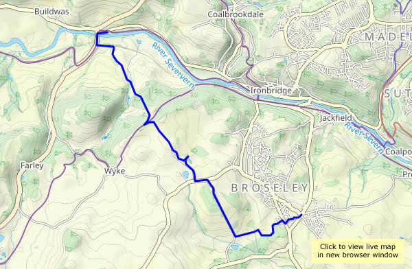
“Are you remembering I’m out this afternoon?” “Yes – can I cadge a lift?” So – I’m walking back from Buildwas, past the park homes and up from the curiously-named Hunger Dale to cross Benthall Edge and head for home past the hall, down Lodge Lane and across the Fiery Fields. Opportunities for point-to-point walks shouldn’t be missed!

View OS map on Streetmap http://www.streetmap.co.uk/map?X=365645&Y=302700&A=Y&Z=120

Barrow sunshine

Tuesday: oilseed rape is this year’s crop in the fields around Barrow, and it’s in full bloom at present. Even when the sun’s behind a cloud, it seems to be shining. Another familiar route – down through the fields and across Barrow Dingle, then up past the church and across the fields to Arlescott and back. In places we’re unavoidably brushing against the crop as we walk – we’re speckled bright yellow by the time we’re back to the start.

View OS map on Streetmap http://www.streetmap.co.uk/map?X=365520&Y=299945&A=Y&Z=120

Rowe Lane and Topley

A fine sunny Sunday afternoon – we’ll make the most of the conditions with a walk from Rowe Lane (near Tigger’s Ickle Shop – we’d better call in for cakes and chutney…) across Corvedale to the Wenlock Edge and back. We follow Rowe Lane southwards, cross the fields near Beambridge and head up the minor road past Millichope Park. Turning back at the westernmost edge, we return past the farm at Topley, pausing to admire its highland cattle (and three little free-range pigs…) before descending beside bright yellow fields, back to Broadstone and Rowe Lane.

View OS map on Streetmap http://www.streetmap.co.uk/map?X=353125&Y=289555&A=Y&Z=120

Jonathan’s Rock and Jinlye

A walk at the northern end of the Long Mynd, starting in Batch Valley. An easy ascent beside the gurgling streamlet in Jonathan’s Hollow takes us up beneath the prominent outcrop of Jonathan’s Rock. As we reach the plateau, a path cuts back to the rock itself (a fine viewpoint), then leads us gently down past the curiously-named Jinlye. After the airy (and breezy) moorland, the descent to All Stretton leads us through quiet bluebell-filled woodlands – quite a contrast. A pleasant little outing!

View OS map on Streetmap http://www.streetmap.co.uk/map?X=345080&Y=296100&A=Y&Z=120

Choc-chip at Coalport

A fine, warm Easter Sunday – can we enjoy an outing without tangling with the crowds?  As expected, we meet no-one on the first couple of miles, down to the old railway line. There we’re passed by a couple of cyclists – then there’s a little passing traffic at the Coalport bridge. After crossing the Severn, we follow the old Coalport railway as far as the china museum – and the youth hostel… Their café is open, there are tables free outside and they’re well-stocked with choc-chip shortbread… Half-an-hour later, we’ve crossed the river again and we’re passing the Boat (doing a good trade in its riverside garden). Then no-one else, apart from a couple of walkers, as we make our way back up the Dingle and head for home. I think we succeeded!

View OS map on Streetmap http://www.streetmap.co.uk/map?X=369245&Y=301430&A=Y&Z=120