Sunny Mynd

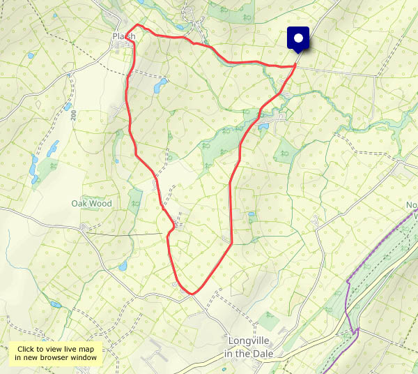
Monday 6 October: What a beautiful afternoon! It would be a crime not to be out on the hills, though we can hardly call this Long Mynd wander a hill walk. We’ve parked the car at about 1530′, and the highest point, Pole Bank, is 1680′. A good leg stretch though, through the rich colours of the autumnal moorland. Returning to the start, we realise we’ve had the best of the sunshine – clouds are starting to gather – but it’s been really pleasant out on these hills

View OS map on Streetmap http://www.streetmap.co.uk/map?X=342385&Y=295030&A=Y&Z=120

Symmetry

Hadn’t realised until I looked at the map! There’s a certain symmetry about an out-and-back route in any case. Not that it has anything to do with the feel of the walk – a real “blow the cobwebs away” struggle against storm Amy, while the few clouds fly past, taking me from light to shade and back in seconds. No great height here, but there are sweeping views to the south – and it really catches the wind. I’m not hanging around!

View OS map on Streetmap http://www.streetmap.co.uk/map?X=366750&Y=296360&A=Y&Z=120

Apple pressing day

A perfect day for it! For a number of years it’s been an annual event at the village hall. There’s no shortage of good fruit around here – this year the crops have been exceptional. It grieves me to see piles of rotting apples where no-one has bothered to pick them, but there are no such piles around Willey (and windfalls are not allowed access to the press). They’ve all been picked and are being chopped by the scratter and squeezed in the press. We’ve parked about a mile and a half away and walked here (the lanes are very narrow and parking could be tricky) so we’ve earned a drink and a piece of (delicious!) home-made cake, bought some local (Willey) honey and had a large bottle filled with golden juice. Something to enjoy over the next day or two…

View OS map on Streetmap http://www.streetmap.co.uk/map?X=367300&Y=297960&A=Y&Z=120

Fungi, hops and berries

Could brew a few pints with the hops around Willey! Pick a hop flower and rub it between your fingers to release that delicious scent. The fungi are beginning to emerge after the recent rain – two beautiful giant puffballs amongst others, and the various fruits and berries are still around in colourful profusion (I think the blackberries are past their best – the devil’s in them from next Wednesday!)

View OS map in Streetmap http://www.streetmap.co.uk/map.srf?X=367470&Y=298250&A=Y&Z=120

Up to Plaish

It’s a hilltop hamlet with a hall. After yesterday’s heavy rain, we’re staying on the (very quiet) surfaced lanes for this walk in Apedale, from the crossroads at Day House, towards Longville then up (it’s no great height, but a gentle pull for the last half-mile) to Plaish. A glance at the hall, a chocolate stop at the field gate – then back down to the start, beside the gurgling little brook, hidden amongst the trees.

View OS map on Streetmap http://www.streetmap.co.uk/map.srf?X=353520&Y=295320&A=Y&Z=120

A Haughmond wander

Another fine afternoon (it can’t last!) – Haughmond Hill could be pleasant. It’s barely worth calling a hill, at 153m above sea level, but the view from the southern edge of the woodland is extensive, a sweeping panorama of significantly higher ground – the Wrekin, the Clee hills, the Stretton hills, the Stiperstones, and away to the west and over the border, the Berwyns. Away from the edge, in the forest, there’s a more limited view, but there’s lots of foreground interest – interesting fungi galore, and a fine crop of tiny sweet wild damsons…

Forestry England: Haughmond Hill

View OS map on Streetmap http://www.streetmap.co.uk/map?X=354525&Y=313810&A=Y&Z=120

The Harton triangle

Dodgy part of the county… No, I’m not aware of a tendency for unexplained disappearances around here, though it is rather quiet (spooky, I suspect, after dark), and very pleasant too beneath the wooded Wenlock Edge. One or two cars passed on the wider lane from Ticklerton to Harton, but the other two sides of the triangle, Harton – Eaton – Ticklerton (see the map below), were almost deserted. We paused to look at the birds at Newhall farm – “come in and have a closer look”, said the friendly lady on her way to feed them. The eagle owl promptly hid when it saw us, but peeped out briefly to see if we were still there. Peacocks, of course, are not so shy…

View OS map on Streetmap  http://streetmap.co.uk/map?X=367550&Y=301475&A=Y&Z=120