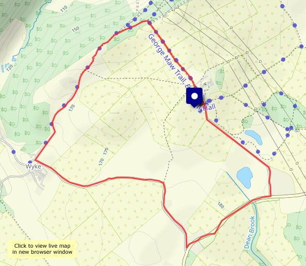
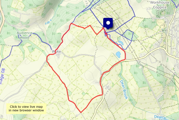
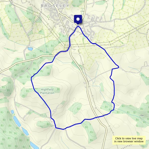
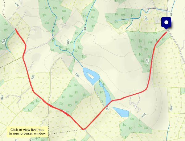
Happy accident

I’d intended to drive down through Harley and beyond – but the Kenley road was flooded (a not uncommon occurence – I should have guessed). So, back to Wenlock, for a walk on the Edge – where I found some yellow brain fungus (aka witches’ butter). Not something I’ve ever seen before. Then (after persevering through sticky mud), what’s that in front? A fox, and he hasn’t seen me (he looked in my direction once or twice, but the sun was bright, low and directly behind me). As I watched, he pounced on some small creature – lunchtime for fox! If I’d been able to follow my plan, my walk might have been much less exciting…

View on Google Earth https://maps.app.goo.gl/HVpGDYJ3MTCp4LwNA

Fungus and ferns

…moss and lichen too. We’re walking downstream from Bedlam, on the old Severn Valley trackbed to Coalport, then back past the china works and over the Jackfield footbridge. It’s a grey day, there’s rain on the way, but it should stay dry for an afternoon leg stretch. The interest is in the detail – jelly ear fungus on elder, some well-hidden elf cups, lovely lichen (needs a really close look), gorgeous green moss and all kind of other vegetation. And though there’s plenty of interest, it’s too cold to stand around for long. Keep moving to keep warm!

View on Google Earth https://maps.app.goo.gl/owhMfW1Wor5Ut7Mn7

The sound of water

Drip, splosh, trickle, roar… The last is an exaggeration: Linley Brook doesn’t roar, but it’s certainly rushing along, and all those other sounds accompany us around these familiar lanes. It’s raining gently (wasn’t supposed to!), and water is running down the road surface, filling the potholes to the brim… At least the snow has all melted (apart from the snowplough dirty heaps beside the road) and that’s the origin of most of the water. At last, just yards from the start, comes that sunny interval we were promised. (No, we didn’t get noticeably wet, and yes, it was good to be out)

View OS map in Streetmap http://www.streetmap.co.uk/map.srf?X=367470&Y=298250&A=Y&Z=120

View on Google Maps https://maps.app.goo.gl/NpE4s7oVqdcitD9z7

After Goretti

On Thursday night, storm Goretti brought us heavy snow – a good 6 inches. The snowfall turned to rain – Friday was a damp, miserable grey and white day. This morning, under a clear sky, the wet snow – still plenty of it – is now hard frozen. It’s not going to be easy underfoot, but I can’t remain indoors all day… The car can stay put again – I’ll walk from home (more-or-less the route we followed eight days ago).

Shorter than intended

Wednesday 7 Jan: Shortly after I got home again, I heard from a good friend. He’d fallen just before Christmas and broken his hip* – and there I was, thinking I’d given up a bit too readily. I’d parked at the bottom and walked up the quiet lane towards Shirlett, intending to go at least as far as the viewpoint across the vale to the Clee hills. The lane was becoming increasingly icy – seriously slippery in places, and not easily avoided. I could have gone flying, and then realised that a passing car could do the same (there are very few up here, but it would only take one). I turned back, feeling less than intrepid. An hour or so later, I realised I’d been sensible (for once, some might say)…

*unlike me, he wasn’t doing anything foolish or unnecessary…

View OS map on Streetmap http://www.streetmap.co.uk/map?X=365020&Y=299063&A=Y&Z=115

Crisp and even

Not deep though… No drifting either – just a thin white layer on the roads and pavements, and other smooth surfaces. On the fields, where there’s a crop emerging, the snow is barely visible, but it’s there. There’s a sizeable flock of lapwings, perhaps 20-30, a very pleasing sight (and sound) in the field on the old opencast site, and over Willey there are several buzzards and three red kites. Beneath a clear blue sky (there are a few distant clouds) and in still air, it’s good to be out with the camera, walking from home via Darley (and the Honeypot!), Willey and Deancorner.  The car hasn’t moved for days!

View OS map on Streetmap http://www.streetmap.co.uk/map.srf?X=367695&Y=300145&A=Y&Z=120

11.30am: Coalbrookdale

Today’s forecast thought it would be cloudy from about 11am – but like yesterday, it wasn’t quite accurate. The sun shone from a clear blue sky all day! In fairness to the Met Office, their cloud map suggested we would be close to the edge of a large area of cloud, and happily today we were the right side of the edge. It was good to be out in the morning anyway, and I suspect Ironbridge, on our route back to the start, would have been much busier this afternoon – well worth avoiding!

… and that’s it for 2025. Happy New Year everyone! “Let’s hope it’s a good one…”


View OS map on Streetmap http://www.streetmap.co.uk/map?X=367295&Y=303911&A=Y&Z=120