Skye: day 3 – the Rha Glen road

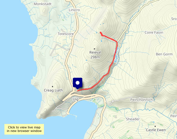
Monday 8 January: almost certainly, this road is thought of by thousands of summer visitors as the Quiraing road. But it’s early January, so the road is quiet – and we’re not heading for the Quiraing. Instead, we’re enjoying the bright sunshine under a clear blue sky. It may be frosty, but there’s not a breath of wind, and apart from one or two cars which pass, it’s completely silent.

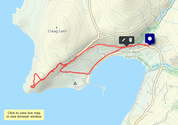
About a mile and a half up the road, a clearly-defined path rises to our left – let’s see how far we can get. There’s an interesting little rocky outcrop, and we can now see beyond the crest of the ridge to Loch Snizort and the outer isles. We could perhaps get a little closer to the edge and look down on Kilmuir? Perhaps not – after a couple of false starts, we realise we’re going to get wet feet, and the sun is getting lower. We’ll head back to the car, parked in the space high above Uig Bay.

View OS map on Streetmap http://www.streetmap.co.uk/map?X=139090&Y=865098&A=Y&Z=120

Skye: day 2 – above Uig

Sunday 7 January: another quiet Skye day – some sunshine, no wind, maybe a spot or two of rain. Parking at the triangle, where the Kilmuir road begins its climb to the hairpin bend and beyond: I’ll walk as far as that bend (endless hours of fun when the tour coaches meet the local bus…) then take to the hill. A good path rises gently to Uig’s landmark headland Creagile. It’s no height – perhaps 300ft above the sea below – but a great viewpoint for the coast to the north and the distant isles. It’s also a great place to watch the 2.30 ferry set out across a calm sea to Lochmaddy, North Uist.

Those spots of rain have timed it nicely – I’m back to the start, it’s not long after 3pm, and it will soon be getting dark…

View OS map on Streetmap http://www.streetmap.co.uk/map?X=138585&Y=864063&A=Y&Z=120

Skye in January

It can be horrendous, with howling gales and lashing rain; however, last week while I was there the weather was kind to me. It was the calmest period I can remember on the island, with lots of sunshine and three days of clear blue skies. Admittedly, the hours of sunshine are very short up there at present. It was very cold, with some hard frosts – a bonus, as the mud I’d expected was hard-frozen!

I left Skye last Saturday, by rail from Kyle of Lochalsh, and travelled down to Dunbar, where I stayed a couple of nights before heading for home yesterday (bringing with me hundreds of photos to work through). I’ll post a selection over the next week or so; in the meantime, here’s a taster – one from each day…

2024: a bright start

…but it’s going to cloud over, and it will rain (again!) later. And tomorrow. We’d hoped for better by now (let’s hope the year performs better than the weather). Anyway, if somewhat muddy underfoot in places, it’s a very enjoyable morning’s wander in the woods and the quiet lanes between Benthall Hall, Wyke and Posenhall (just a short stretch of busier road between the latter and the end of Benthall Lane, and I get the feeling than many must be sleeping off last night’s excesses).

View OS map on Streetmap http://www.streetmap.co.uk/map?X=365560&Y=302470&A=Y&Z=120

Severnside structures

A short morning walk – it could rain later, but it should stay bright before lunchtime. I’ll set out across the Free Bridge, cross the river again by the memorial footbridge, then head down past the china works to Coalport Bridge. There’s some blue sky now, but I’m on the shady side of the valley and the sun’s not really trying anyway. Half-an-hour after I’ve arrived home, it’s raining…

View OS map on Streetmap http://www.streetmap.co.uk/map?X=368755&Y=302490&A=Y&Z=120

A walk of two halves

For the first mile and a third I’m on the surfaced lane from the Shirlett road junction. The views (when I’m not in the forest) are extensive – the Berwyns in Wales, the Malverns (just) – and there’s a steady breeze. Then I’m heading down Ned’s lane, along the very minor road through the Smithies and back up Round Hill – and down there it’s a different world, in more ways than one. Its certainly much less windy! After Round Hill, I’m retracing my steps to the start, and already the light is going. It’s been an very enjoyable wander in this quiet part of the world

View OS map on Streetmap http://www.streetmap.co.uk/map.srf?X=366240&Y=297950&A=Y&Z=120