Heribusta

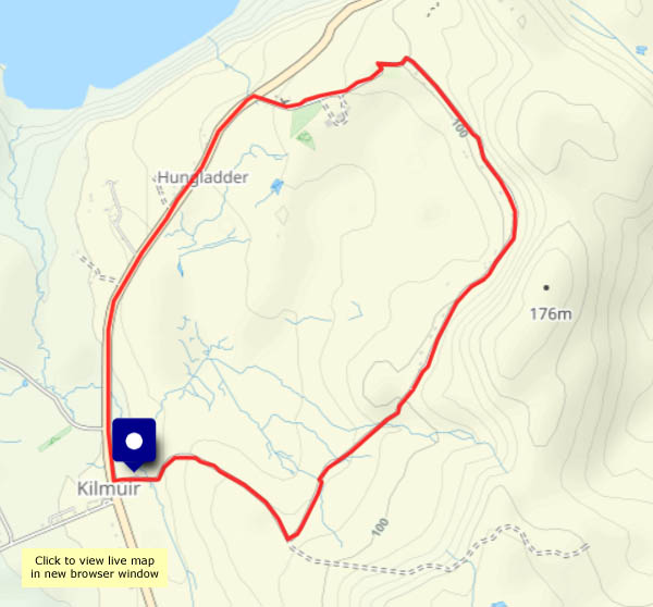
Thursday 15 February: A rainy day. It was heavy before lunch, but the afternoon looked better. Not sunny, still damp, not actually raining… The ground is sodden, and there’s running water everywhere – I’ll stay on surfaced roads. The minor road from Kilmuir village hall leads up into the hills, through the curiously-named settlement of Heribusta, looping back to the main road not far from the cemetery where Flora (“Over the sea to Skye”) Macdonald lies. Nothing passes me – no cars, no-one on foot (a golden eagle, forced down from higher ground by the mist, cruises past briefly). The main road back to the village hall (A855, single track with passing places) isn’t much busier – a couple of cars and a van perhaps. An enjoyable outing!

View OS map on Streetmap http://www.streetmap.co.uk/map?X=139435&Y=870985&A=Y&Z=120

An Uig paper round

Saturday 17 February: Need a leg-stretch, and the weatherman says it will rain this afternoon. We need to go down to Uig for today’s paper – perhaps we can end our walk at the shop. The papers should be in by then – they don’t get here until late morning (many years ago, I had a paper round. I was hopeless – usually half-asleep, I pedalled around on autopilot. Rarely did my last delivery coincide with the last paper in my bag. I might have been more successful if the papers arrived at noon)

The jelly-ear fungus was a welcome find, on some scruffy elder bushes beside the Idrigill road. There was another very substantial crop a few yards further back, but the thicket of dead brambles looked impenetrable and rather scratchy…

View OS map on Streetmap http://www.streetmap.co.uk/map?X=139050&Y=863942&A=Y&Z=115

Coast to coast…

Friday 16 February: Easy! The east and west coasts of Skye’s Trotternish peninsula are about a mile and a half apart here, almost at the northern tip. This is my October walk ‘Walking in reverse – the Skye Trail‘ – in reverse! Makes a great circular route, even if that means walking along the road (very quiet at this time of year) – and it’s a perfect afternoon. Bright sunshine, blue sky, just the slightest breath of wind, almost no-one else around – what more could one ask?

View OS map on Streetmap http://www.streetmap.co.uk/map?X=142254&Y=875148&A=Y&Z=120

Balmaqueen – filling the gap

Tuesday 13 February: it didn’t really need filling – I’ve walked along this spectacular stretch of coastline several times. Last October, I walked the northernmost part of the Skye Trail (in reverse) between its start at the Shulista road end and Port Gobhlaig. Last month I walked the stretch between the old radar station at Balmaqueen and Flodigarry. Today I’m filling the gap.

Don’t be misled by the photos. Yes, beautiful blue sky and white fluffy clouds; one or two showers about, though not where I am. But there’s a cold, strong and buffeting westerly wind, trying to hurl me off the clifftops. I’m keeping well back from the edge today…

View OS map on Streetmap http://www.streetmap.co.uk/map?X=144334&Y=874324&A=Y&Z=120

Hinnisdal woodland

Wednesday 14 February: a quiet wander along the Hinnisdal forest road, on a calm and grey afternoon. Yesterday afternoon I was nearly being blown off my feet – today there’s barely a breath of wind. As with other wooded parts of the island, the trees are accompanied by moss and lichen, and despite the trees, there are some fine views out to sea and up the glen.

View OS map on Streetmap http://streetmap.co.uk/map?X=140500&Y=857500&A=Y&Z=120

Duntulm and Cnoc Roll

Sunday 11 February: visitors to Skye flock to it in their thousands during the season, though I suspect most of them drive away thinking “what was that all about?”. Its situation may be dramatic, but it’s hardly Tantallon, Eilean Donan or Dunnottar – there’s very little left of Duntulm castle. The parking space beside the road provides me with a starting place for this short walk, and I’ll start with a look at the castle from the shore.

Five minutes later I’m heading past the former coastguard cottages to take the farm track around the back of Cnoc Roll, a small hill topped by a radio mast. The track goes all the way round, but at the half-way mark an old way leads to the opposite hillside, for great views and a slightly longer walk. There are no paths up here, but the way is pretty obvious, if steep and in places soggy…

View OS map on Streetmap http://www.streetmap.co.uk/map?X=141205&Y=874010&A=Y&Z=120


Rain forest

Monday 12 February: no, it’s not a forest – just a strip of woodland by the shore of Uig bay. ‘Just’ is, however, understatement. It’s a tiny fragment of temperate rain forest. Look at it! Mosses and lichen everywhere in profusion. The liverwort is amazing – great green cabbage-like growths, while the extensive moss, covering everything that hasn’t moved for a while, is – green! The threatened rain is now falling heavily – we’ll scuttle back along along the path before we’re soaked

View OS map on Streetmap http://www.streetmap.co.uk/map?X=139475&Y=863874&A=Y&Z=115

A stranger at Uig

Monday 12 February: Driving into Uig around lunchtime, we looked to the sea. “The ferry’s coming in”. Doesn’t usually arrive just now – usually gets in around 1.30. It’s a funny shape too – rather squat and low in the water… The binoculars make it clear – it’s catamaran Alfred belonging to Pentland Ferries. A little later, an internet check solved the puzzle. It’s on hire to Calmac from today, while the Hebrides goes in for scheduled overhaul. It should soon be replaced by Calmac’s Clansman, fresh from its own overhaul. Will we see it? Three different vessels in a week?