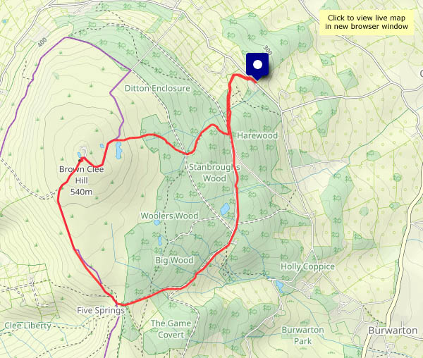
Leven – back to Fife

Thursday 27 June: A day out from Dunbar, to ride on the recently-reopened line to Leven, on the shores of the Firth of Forth in Fife… I’ll change trains at Kirkcaldy (for a brief exploration), and on my return I’ll stop for a few photos at the lovely little station at Aberdour (see above). Visit ‘Leven… Kirkcaldy and Aberdour’ on Geoff’s Rail Diaries for a full illustrated account of the rail-related aspects of this most enjoyable outing.

East Coast

Tuesday 25 June and Wednesday 26 June: Montrose, the ‘East Neuk’ of Fife and Dunbar. It was a gloomy Tuesday evening in Montrose. Better tomorrow? No! Scotland’s east coast was suffering from a ‘haar’ (what my mother called a ‘sea fret’). The fishing villages – we visited Crail and St Monans – can be very picturesque with a spot of sunshine; they were eerily quiet in the mist. By evening, we’re in Dunbar, and I’m stretching my legs before calling it a day.

Dunvannarain and Meall Tuath

As mentioned in yesterday’s post, Sunday’s weather was much more friendly – bright, some pleasant sunshine, and sufficient breeze to keep the midges away… I’ve walked this circular route a couple of times recently – it’s the first few miles of the Skye Trail, linking the small car park at the Shulista road end with Kilmaluag old churchyard, or Cladh. As there’s space at the former, I’ll start there – and walk the route anti-clockwise, to get the road walk done first (it’s not bad – not much traffic this afternoon).

Once off the road, the walk is very enjoyable, passing the old settlement (now home to lots of rabbits) and cairn at Dunvannarain on its grassy ridge. Soon I’m at the cliff edge, and the coastal scenery is spectacular as far as the bothy (a former coastguard look-out) on Meall Tuath. After the compulsory choc-stop (there’s a perfectly-placed bench), the return to the start is easy and pleasant – a well-trodden way, much improved in recent years, with great views to the western coastline of Trotternish, the sea sparkling in the sunshine.

View OS map on Streetmap http://www.streetmap.co.uk/map?X=142365&Y=875170&A=Y&Z=120

Lenticular

After several almost sunless days, it’s been a much better day. One result is lots of photos to work through, but they’ll have to wait. Here’s just one taster – a remarkable evening cloudscape at the northern end of Trotternish, with the scattered houses of Bornesketaig in the middle distance.

A Reieval ramble

It’s no great height – 299m, according to the Ordnance Survey – but it’s high enough on (yet another) windy day. Fortunately there are some comfortable rocks, perfect for a chocolate stop, just to the leeward side of the summit. Before I take to the hill, I’m walking along the road from Uig to the Quiraing. Judging by the number of cars, SUVs, camper vans and minibuses on this narrow road, it will be horribly busy there. Reieval may not be quite so scenic (or well-known), but it’s a great place to sit and survey the scene – and there’s no-one else there.

View OS map on Streetmap http://www.streetmap.co.uk/map?X=139255&Y=864868&A=Y&Z=120