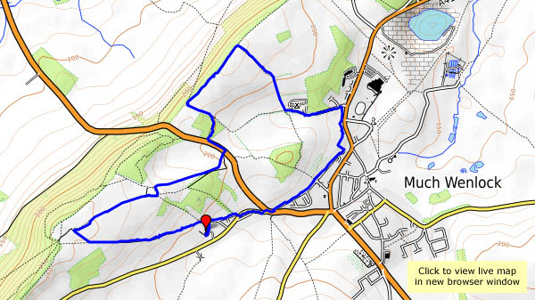
The afternoon is wearing late – there’s only time for a short walk. We’ll have a wander around Wenlock…


 View OS map on Streetmap http://www.streetmap.co.uk/map.srf?X=361440&Y=300141&A=Y&Z=120

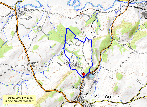
The afternoon is wearing late – there’s only time for a short walk. We’ll have a wander around Wenlock…
View OS map on Streetmap http://www.streetmap.co.uk/map.srf?X=361440&Y=300141&A=Y&Z=120
… lies Queenswood, an area of managed woodland with, at its heart, an arboretum – just the place for an outing on a cold but sunny day. It’s a popular spot – there’s a party of very small schoolchildren gathering leaves, numerous young mums and offspring, and the inevitable dog-walkers, but away from the autumnal specimens and the viewpoint (too hazy today for really good views) it’s quiet, and very pleasant too.


View OS map on Streetmap http://www.streetmap.co.uk/map.srf?X=350460&Y=251080&A=Y&Z=120
The clocks have gone back – it’ll be dark early, and we’re making the most of a fine sunny afternoon. Wenlock to Bannister’s Coppice will be a pleasant stroll – perhaps we’ll see some deer? We did – a sizeable herd, in the depths of the wood, just distant shapes moving quickly but quietly between the trees. No chance of a photograph. What we did achieve was a photographic record of a red kite, quite accidentally. I only saw it when checking through the photographs later – that speck in the sky has a pretty distinctive shape…


View OS map on Streetmap http://www.streetmap.co.uk/map.srf?X=362135&Y=302151&A=Y&Z=120
Friday 27 October – a bright sunny day, far too good for staying at home, so we’ve packed a picnic… It’s very busy in Church Stretton, but we soon lose the crowds – the Pike provides a quick way up onto the hill, at the top corner of the golf course. At this point, we attempted to follow the path clearly shown on the OS map, which is a mistake, as it doesn’t exist. The clear, easy-to-walk path is 100 yards to our left, higher up the hill. At least its quiet along here…
We take our lunch break by the pond, near the top of Mott’s Road, before heading to the summit, then returning to the car by Townbrook Valley. It’s a bit quieter down here – and finally, we time the tea room to perfection… A good day out!


View OS map on Streetmap http://www.streetmap.co.uk/map.srf?X=343320&Y=295091&A=Y&Z=120
It’s busy on the Stiperstones this afternoon – lots of black sheep, at least two red kites, a grouse, a good number of alpacas and several llamas. There were quite a few people too, in the more popular parts – something to do with it being half-term, and the weather fine, clear and sunny? Young parents and children, a largish party armed with pointy sticks and a large group of – were they schoolteachers? Our greatest fear was that they might arrive at the Bog before we did, and that it might be packed anyway. Our fears were unfounded – just a medium-sized group around one of the tables, and it seems one of us knew them all anyway, so that was OK. The tea and cakes were, as ever, excellent (and well-earned, of course).


View OS map on Streetmap http://www.streetmap.co.uk/map.srf?X=336375&Y=297956&A=Y&Z=120&ax=335475&ay=299701
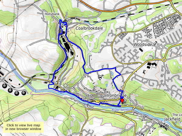
The remains of the ancient iron furnaces at Bedlam were open to the elements until very recently – now they have a cover – a canopy with substantial steel supports. We’d better take a look. Afterwards, we’ll wander over the hill, and down Church Road, viewing the closed power station through the trees (there’s a common theme to this little walk…). At the top end of Coalbrookdale the viaduct no longer serves its purpose. The woodland path to the old railway station, now in the care of the Green Wood Centre, overlooks the iron works, soon to cease production. It’s been a quiet walk so far, but now we’re dodging the many visitors to Ironbridge as we walk beside the river back to the car. At least one thing is still thriving here.


View OS map on Streetmap http://www.streetmap.co.uk/map.srf?X=367367&Y=304093&A=Y&Z=120
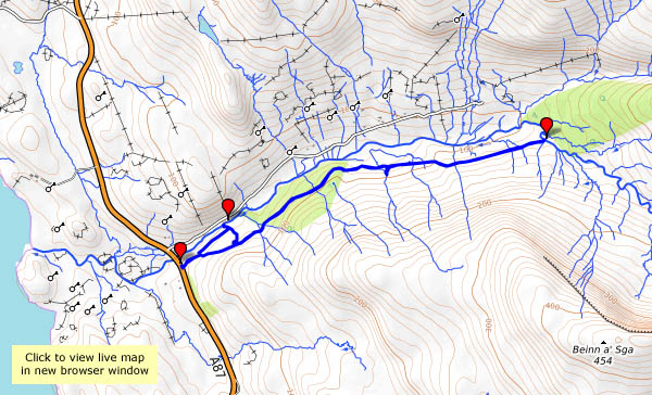
Wednesday 18 October: a quieter day – the wind has dropped, it’s dry, and it’s mostly dull. There’s no drama in the lighting, but we’ll take the camera anyway, for a walk up the Hinnisdal forest road. We need a leg stretch, and there’s a good surface here, all the way to the ford – which today is unfordable. The stepping-stones are submerged in October. We’ve walked far enough now, and though we’ll be retracing our steps, the views are different.


View OS map on Streetmap http://www.streetmap.co.uk/map.srf?X=141372&Y=857825&A=Y&Z=120
Tuesday 17 October: Ophelia has passed, the wind has swung around to the north, and the waves are whitening the north Skye shoreline. I’ll start at Camas Mòr, then take a look at the view from the Bornesketaig clifftops. I’m catching the full force of the wind here – apart from a narrow zone a few feet back from the cliff edge (curious!). There’s a shower coming – back to the car quickly! On now to Balmaqueen, and the shore path towards that little white house on the edge of nothing. Surely it must get washed away?


Monday 16 October: the remains of hurricane Ophelia are turning the sky a strange colour further south. Here, it’s just grey, showery and very windy – it’s not fit to stray far from the car. We make a false start in Hinnisdal, before heading towards Dunvegan. At Edinbane, we turn around and take the side road to Fanks, timing it nicely for a gap in the cloud. Suddenly, there’s a little golden islet in loch Snizort, though it’s not quite aligned with the end of the rainbow. The scene before me is wonderful, though once again I’m struggling to hold the camera steady. Little more than half-an-hour later, the sunshine has gone and we’re back to dull, grey landscapes. And the wind.


Sun 15 October: it’s still very windy, with lots of showers and occasional bursts of sunshine. Saturday was grey and relatively calm, so we were on garden duties; today we need a change of scene, so we’re out in the car, hoping for dry spells and those elusive sunny intervals. We’ll start off at Staffin slip, then head down the east coast as far as the viewpoint above Rigg bay. Retracing our steps, there’s a brief brighter spell by loch Mealt, then, pausing by Score bay, the floodlights are switched on to illuminate what’s left of Duntulm castle.


