
 It’s been a little while since I updated the “Walks with a Camera“. It’s not that we haven’t been out and about – far from it. However, most expeditions in the last 12 months or so have been fairly short local wanders, which hardly seemed to deserve a page (perhaps, before too long, some “Shropshire Shorties”?)
Anyway, here’s an account of a reasonable-length ramble to the top of Shropshire’s highest hill – at 1772′, surely it deserves a page of its own? Visit “Brown Clee and the Boyne” for the usual illustrated account.
Category: Walks
Short walks with photos and a Google map.
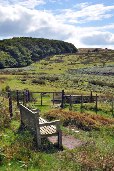
The other side of the Mynd
 It’s almost the end of May, and a pretty poor week it’s been, weatherwise. But the forecast for Thursday was good – time for a walk, in the south Shropshire hills. We’ve walked up the Long Mynd’s eastern valleys many times – today we would walk from the west, exploring some very quiet country (and finishing with a fine pint at the Horseshoe Inn). Visit “Back of the Mynd” on “Walks with a Camera”
Kerry Hill wandering

Friday 8th Feb: The weather in Shropshire was sunny – Kerry Hill wasn’t, though the sun tried (and failed) to break through from time to time. Visit “Kerry Hill” on “Walks with a Camera” for a full account of our explorations in the Welsh border country
Third time lucky – Moel Fferna
 No, not our third attempt at the fearsome north face of Moel Fferna – but a third fine, clear, sunny day out in the wettest July ever! 12 months ago we were struggling to get a walk or two in the hottest July ever…
A 2000′ summit in the northern Berwyns, and a derelict slate mine, once served by Britain’s last wooden railway – visit “Moel Fferna” on “Walks with a Camera”
Hayfield – Kinder Downfall
 It’s pouring with rain again, and the south Midlands are suffering from severe flooding – but a couple of days ago, we carped the diem, so to speak, and took to the hills, this time to follow the route of the famous mass trespass of 1932 up to the Kinder Scout plateau. We would then follow the edge, with its wonderful gritstone formations. past Kinder Downfall, before (almost literally) squaring the circle via Kinderlow End.
Visit “The Trespass” on “Walks with a Camera”
Llandegley Rocks
 As I write, the rain is teeming down – another wet day in this soggy summer. But a couple of days ago, we had an excellent 10-mile stroll on little-known hills in mid-Wales. Perfect walking conditions – pleasantly warm, a light breeze, red kites, mud…
Visit “Llandegley Rocks” on “Walks with a Camera”
Hergest Ridge

A walk along this fine ridge on the Herefordshire – Radnorshire border, on a bright March day. Visit “Hergest Ridge” on “Walks with a Camera”
Walks with a Camera – Books and Maps ctd…
Finished! At the very least, the map(s) used to plan the walks are listed. And except where indicated, they’re all maps I own and have checked to make sure the walk is actually covered by that particular map. Most of Wainwright’s little books are listed too – they’re still invaluable in planning a day out, in the areas they cover. What a shame he never did Shropshire!
I’d be interested to hear from site visitors whether they find the “Books and Maps” useful…
Quiet hills on the Welsh border
 A post-Christmas day out on the lonely hills just across the Welsh border, south-west of the Teme valley. Great walking country, and barely a soul to be seen all day. A mild southerly breeze, sunshine, blue skies and white puffy clouds – what more could one have asked for, after the miserable foggy weather over Christmas. Visit “Beacon Hill (Powys)” on “Walks with a camera”
Northumbria published
“Northumbria” now up on “Walks with a Camera” – text and pictures of the trip to Hadrians Wall, the Cheviots and the scenic Northumbrian coast
